BC 15-minute City Movement Gains Momentum in 2026
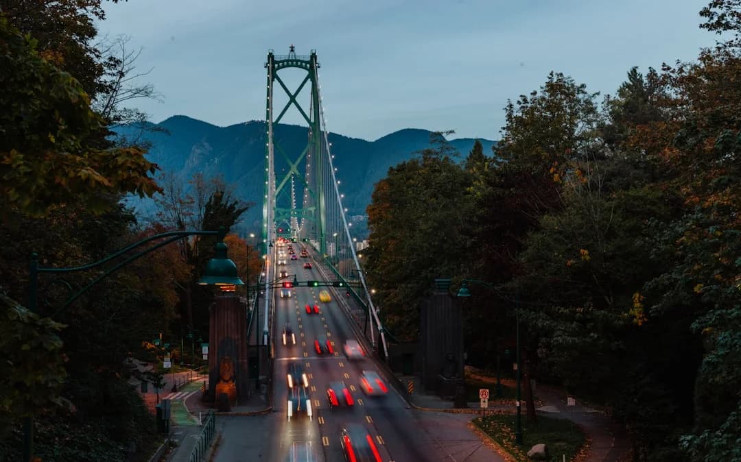
Photo by Priscilla Du Preez 🇨🇦 on Unsplash
British Columbia’s urban landscape is entering a defining chapter for the BC 15-minute city movement in 2026. As Vancouver rolls out high-visibility pedestrian zones and aligns its mobility strategy with multimodal options, policymakers, businesses, and residents are watching how proximity, accessibility, and safety translate into real-world outcomes. In the lead-up to a bustling World Cup summer and a province navigating growth and climate targets, the latest moves in British Columbia’s largest city illustrate how a data-driven approach to urban form can steer both public safety and market dynamics. The core question for readers is simple: can walkable, mixed-use neighborhoods become the default, not the exception, in British Columbia—and what does that mean for technology-enabled mobility, real estate, and city services? The answer is increasingly grounded in concrete actions, pilots, and policy shifts that tie directly to the BC 15-minute city movement and its implications for businesses and residents alike. (vancouver.ca)
In June 2026, Vancouver took two high-profile steps that sharpen the practical edge of the BC 15-minute city movement. First, the Granville Street Pedestrian Zone—the heart of downtown—launched as a temporary, World Cup–themed pedestrian corridor running from June 12 to July 19, 2026, with bus routes reoriented and new public amenities deployed to support both residents and visitors. The move is part of a broader trend toward reclaiming streets for people, aligning with the city’s longer-standing ambitions to weave essential services into shorter travel distances for residents. Mayor Ken Sim framed the move as a chance to “welcome residents and the world” to a core shopping and cultural district, while Downtown Van and city staff prepared activations and supports for local businesses. (vancouver.ca)
Less than a week later, Vancouver’s City Council approved the Vision Zero Safe Mobility Plan, a data-informed framework aimed at reducing traffic fatalities and serious injuries on city streets by at least five percent each year on a path toward zero before 2050. The plan emphasizes a “safe systems” approach, prioritizing pedestrian safety, improved crossings, and targeted infrastructure at high-risk locations. The policy signals a broader shift toward mobility that prioritizes people over vehicle throughput, a core tenet of the BC 15-minute city movement as it seeks to knit together walking, biking, transit, and short trips into a more resilient urban fabric. (vancouver.ca)
As part of the same mobility conversation, the City of Vancouver highlighted additional pilot work that complements the 15-minute city goal. Notably, the Gastown Water Street Pedestrian Zone is planned to return for summer 2026, with Sunday road closures from noon to 8 pm between July 5 and September 6, in collaboration with the Gastown Business Improvement Society. The plan reflects a broader appetite for temporary pedestrianized corridors to test, measure, and refine how dense, mixed-use neighborhoods function when streets are opened up to people-first programming and events. The Gastown initiative follows positive signals from 2025 surveys and represents a measurable step in converting proximity into everyday life experiences. (voiceonline.com)
Opening the broader conversation beyond Vancouver’s downtown core, several studies and industry analyses provide essential context for what these moves mean for technology-enabled mobility and market trends in British Columbia. A 2022 SFU study cited by industry outlets quantified how much Vancouver residents already live within practical walking or biking distances to groceries and daily needs, underscoring that the city’s “amenity density” could support a wide adoption of 15-minute city principles. The study found that 79 percent of Vancouverites had access to a grocery store within a 15-minute walking distance and 99 percent within a 15-minute biking distance, while also highlighting inequities that policymakers must address to make such proximity universally accessible. This work has informed subsequent planning discussions about land use, density, and accessible transportation as central to achieving the 15-minute city vision. (eurekalert.org)
Deloitte Canada’s 2022 study on bringing the 15-minute city to life frames the topic through a technology and market lens. It emphasizes dense, transit-oriented development and pedestrianization as mechanisms to reduce emissions, improve livability, and attract talent—while underscoring the need to integrate mass transit with micro-mobility solutions such as bike shares and car shares. The report also notes that the private sector has a key role in helping people access daily needs more efficiently, which has implications for infrastructure investments, public–private partnerships, and data-enabled mobility services. While not BC-specific, the analysis provides a practical framework for interpreting Vancouver’s pilot projects and safety investments within a broader Canadian context. (www2.deloitte.com)
Alongside these planning and policy developments, technology-driven trials and pilot programs in the Vancouver region underscore the growing convergence of mobility tech, safety, and urban form. CityNews Vancouver coverage in 2026 highlighted a six-month pilot for delivery robots in downtown cores, moving from concept to limited operation and signaling a willingness to test novel urban logistics models within a regulated, safety-focused framework. The pilot—paired with provincial regulatory steps—illustrates how the BC 15-minute city movement can intersect with cutting-edge urban technologies, remote work trends, and consumer expectations for rapid, local services. (vancouver.citynews.ca)
The momentum around BC’s 15-minute city concept is also mirrored in regional mobility and climate action discourse. In June 2026, Vancouver reaffirmed its emphasis on pedestrian and multimodal infrastructures within a broader climate strategy that seeks to balance safety, mobility, and efficiency. The city’s framing ties directly to a climate and health objective—getting more residents walking, rolling, or taking transit to daily activities rather than relying on cars. The results of these policy choices are already shaping the market, with infrastructure investments, transit planning, and private-sector participation increasingly connected to the idea of neighborhood-scale access and reduced travel times. (vancouver.ca)
Section 1: What Happened
Granville Street Pedestrian Zone Activation
The Granville Street Pedestrian Zone represents a bold, time-bound test of a car-free downtown spine during a global event. Running from June 12, 2026, through July 19, 2026, the five-block stretch from Georgia Street to Davie Street is being transformed into a pedestrian-focused hub with enhanced seating, activations, and support for local businesses. The City of Vancouver, in partnership with Downtown Vancouver and other partners, has approved bus re-routing along Seymour and Howe streets and introduced a new downtown bus route to meet heightened demand. The plan also maintains emergency vehicle access and calibrates street operations to balance the pace of a World Cup-impacted city with ongoing mobility needs. City officials described the pedestrian zone as a chance to showcase Vancouver’s capacity to host major events while testing a public-space-first approach to urban life. Key elements include self-guided experiences, soccer-themed activations, and a robust programming calendar designed to sustain energy across blocks while serving residents and visitors. The initiative is part of a broader trend in Vancouver toward neighborhood-scale activation and pedestrian-first street design as a core element of the BC 15-minute city movement. (vancouver.ca)
Vision Zero Safe Mobility Plan Adoption
On June 10, 2026, Vancouver City Council approved the Vision Zero Safe Mobility Plan, a policy framework built around the principle that streets should be designed to minimize harm and improve safety for all users. The plan pivots on data-informed prioritization of high-risk locations and aligns with regional and provincial safety targets. The plan’s core actions include: continuing to address safety hotspots with proven measures such as leading pedestrian intervals, upgraded signals, and advanced turn signals; updating design standards to reflect best practices for pedestrian priority; and delivering quick-build pilots to improve safety on identified corridors, including Hastings Street in the Downtown Eastside. The adoption signals a deliberate shift toward safer street environments that support walking and cycling as feasible alternatives for everyday trips, a fundamental prerequisite for the BC 15-minute city movement. (vancouver.ca)
Gastown Public Spaces Plan and Water Street Pedestrian Zone
Vancouver’s Gastown neighborhood is also advancing the public-spaces framework that encourages people-first planning and flexible, multimodal street use. The Gastown Public Spaces Plan was approved in April 2026, and it establishes a long-term vision for a people-first neighborhood that supports daily life, commerce, and public events. The Water Street Pedestrian Zone—a legacy of earlier pilots and public engagement—will return in summer 2026, with structured Sunday closures that enable pedestrian activity, markets, and programming on a corridor that is central to Gastown’s identity. The plan underscores the city’s willingness to test pedestrianization, seasonal activations, and corridor redesigns as levers for achieving proximity and access in dense urban settings. The public support reflected in 2025 surveys—84 percent of respondents in favor of returning the pedestrian zone—helps validate a data-driven approach to expanding “complete streets” concepts across the region. (voiceonline.com)
Broader Context: SFU and Industry Perspectives
The Vancouver case sits within a larger discourse on the feasibility, equity, and governance of 15-minute city policies. SFU’s 2022 study—widely cited in industry and media outlets—found that a substantial share of Vancouver’s population already enjoys close proximity to groceries, but it also highlighted inequities that require targeted interventions. The study’s emphasis on land-use mix, density, and access highlights why mobility planning in BC must be data-driven and equity-focused as the region experiments with pedestrian zones and multimodal networks. A 2022 Weather Network piece echoed those findings, noting that Vancouver’s Climate Emergency Action Plan targets—such as achieving a high share of residents within easy walking distance by 2030—create a clear policy anchor for BC’s 15-minute city movement. Together, these studies provide the evidence base and policy justification that underpin the city’s pilot programs and safety investments. (eurekalert.org)
Section 2: Why It Matters
Mobility Safety and People-Centered Design
The Vision Zero Safe Mobility Plan’s adoption in June 2026 marks a decisive shift toward safety-first street design, a prerequisite for any successful 15-minute neighborhood strategy. The plan’s approach—prioritizing pedestrians and vulnerable road users, deploying quick-build safety improvements, and integrating equity considerations—addresses a long-standing concern that proximity alone does not translate into livability if streets remain dangerous for everyday walkers, cyclists, and transit users. City officials emphasize that the plan uses collision and injury data to prioritize locations and deploy evidence-based interventions, a practice aligned with modern mobility analytics and public health goals. As Vancouver moves to balance safety with mobility and efficiency, the plan serves as a blueprint for other BC communities considering similar transitions from car-centric to people-centered urban forms. (vancouver.ca)
Economic and Social Equity Implications
The 15-minute city concept promises accessibility improvements, but it also raises questions about equity. SFU’s Vancouver study identified neighborhoods where improved access to groceries and services is most needed—typically areas with higher concentrations of children, older adults, and marginalized groups. The practical challenge is ensuring that new or expanded amenities, transit options, and pedestrian infrastructure do not disproportionately benefit already well-served communities. This tension between proximity and access highlights the need for targeted investments and careful monitoring to ensure the BC 15-minute city movement genuinely expands opportunity rather than simply redefining the map of convenience. Policymakers and planners are increasingly looking to data dashboards and continuous public engagement to measure progress against equity benchmarks as part of Vancouver’s broader growth and climate strategies. (eurekalert.org)
Technology, Data, and Market Trends
The BC 15-minute city movement sits at the nexus of technology, mobility platforms, and urban policy. Deloitte’s framework emphasizes integrating mass transit with micromobility solutions and leveraging data to optimize routes, schedules, and land-use planning. For Vancouver, that translates into a market environment where transit operators, ride-hailing, bike-share, and last-mile logistics providers may need to coordinate more tightly with city planning. The approval of a delivery-robot pilot further demonstrates how new technologies can be tested within a regulated framework to understand their impact on urban space, safety, and efficiency. For businesses, this is a signal to watch for regulatory changes, public-private partnerships, and potential pilots that test new urban logistics or last-mile services within a 15-minute-city context. (www2.deloitte.com)
Broader Regional and Climate Context
The BC 15-minute city movement is not only about Vancouver’s city center; it links to Metro Vancouver’s regional planning and climate-action objectives. Metro Vancouver’s climate-action progress and the City of Vancouver Plan emphasize the importance of accessible parks, green infrastructure, and transit-oriented development as part of a broader strategy to reduce emissions and improve livability. While the primary evidence in public sources focuses on Vancouver, the regional planning context suggests a wider adoption path for nearby municipalities seeking to align with transit-oriented growth and walkable neighborhoods. This regional lens matters for investors, developers, and tech firms evaluating the BC market’s potential to create value around proximity-based services, smart mobility apps, and climate-positive urban design. (metrovancouver.org)
Section 3: What’s Next
Timeline, Milestones, and Next Steps
Looking ahead to summer 2026 and beyond, the immediate milestones include the ongoing Granville Street Pedestrian Zone through July 19, 2026, followed by continued programming and evaluation of its impact on foot traffic, local businesses, and street safety. The Gastown Water Street Zone’s summer schedule—July 5 to September 6, with Sunday closures—offers a concrete, recurring test case for the city’s approach to pedestrian-first corridors and event-driven activation. City staff will closely monitor safety, economic impacts, and user experience, using these results to refine design standards and program guidelines across other neighborhoods. In parallel, the Vision Zero Safe Mobility Plan will continue to guide investments and policy changes on a rolling basis, with emphasis on priority corridors and quick-build interventions that can be scaled if successful. (vancouver.ca)
What to Watch For in 2026–2027 and Beyond
Several observable trends are likely to shape the BC 15-minute city movement in the near future:
-
Expanded pedestrianization pilots across additional districts, driven by public engagement and economic data from pilot zones. The Gastown example demonstrates how neighborhoods can adopt seasonal, event-driven pedestrian corridors to test livability and vitality metrics.
-
Enhanced multimodal networks that integrate transit, cycling, and walking with micro-mobility options and short-haul last-mile services. Deloitte’s framework suggests synergy between mass transit and micromobility that can be accelerated through data sharing, standards, and pilot programs.
-
Data-driven performance metrics that track accessibility, safety, and equity. SFU’s work and subsequent city planning efforts highlight the importance of measurable indicators—such as proximity to essential services, safety outcomes, and transit accessibility—that inform policy adjustments and investment decisions.
-
Private-sector participation in urban logistics and mobility services, balanced by regulatory safeguards. The delivery-robot pilot in downtown Vancouver is a case study in how new technologies may be introduced with a clear governance framework, public safety commitments, and performance evaluations that inform future policy decisions. (vancouver.citynews.ca)
-
Climate-action alignment and resilience considerations. Vancouver’s mobility investments and public-space strategies are increasingly embedded within climate targets and health outcomes, reinforcing the business case for proximity-based cities as a catalyst for more sustainable growth. (vancouver.ca)
Next Steps for Readers and Stakeholders
For residents, businesses, and developers, the most immediate actions are to stay informed about pedestrian-zone schedules, safety improvements, and new mobility options in your neighborhood. City websites and local news outlets provide real-time updates on planned events, temporary closures, and street-use changes that could affect daily routines. For companies, monitoring the evolving regulatory framework around mobility and urban-tech pilots—particularly those connected to safe-mobility initiatives and last-mile services—will be essential for strategic planning and potential partnerships with city programs. And for policymakers, the focus remains on delivering measurable improvements in safety, accessibility, and equity while maintaining a flexible approach that allows neighborhoods to evolve toward shorter travel distances without compromising quality of life.
Closing
In British Columbia, the BC 15-minute city movement is translating from a planning concept into on-the-ground action, with Vancouver testing pedestrianized corridors, safety-centric mobility plans, and neighborhood-scale street design. The crosscurrents of World Cup planning, Vision Zero safety targets, and neighborhood pilots create a dynamic environment where proximity and access are measured not just in meters but in lived experience—how quickly a resident can reach a grocery store, a clinic, a school, or a park on foot or by bike, and how safely they can navigate the streets to do so. The coming months will show whether these pilots can scale across more neighborhoods, how equity considerations are addressed through data and engagement, and how technology-enabled mobility services—delivery robots, bike shares, and multimodal networks—can support a resilient, inclusive, and prosperous 15-minute city future in British Columbia. Stay tuned as BC Times continues to track the evolving intersection of technology, policy, and urban life in the BC 15-minute city movement. (vancouver.ca)