Pattullo Bridge replacement opens February 14, 2026 (BC)
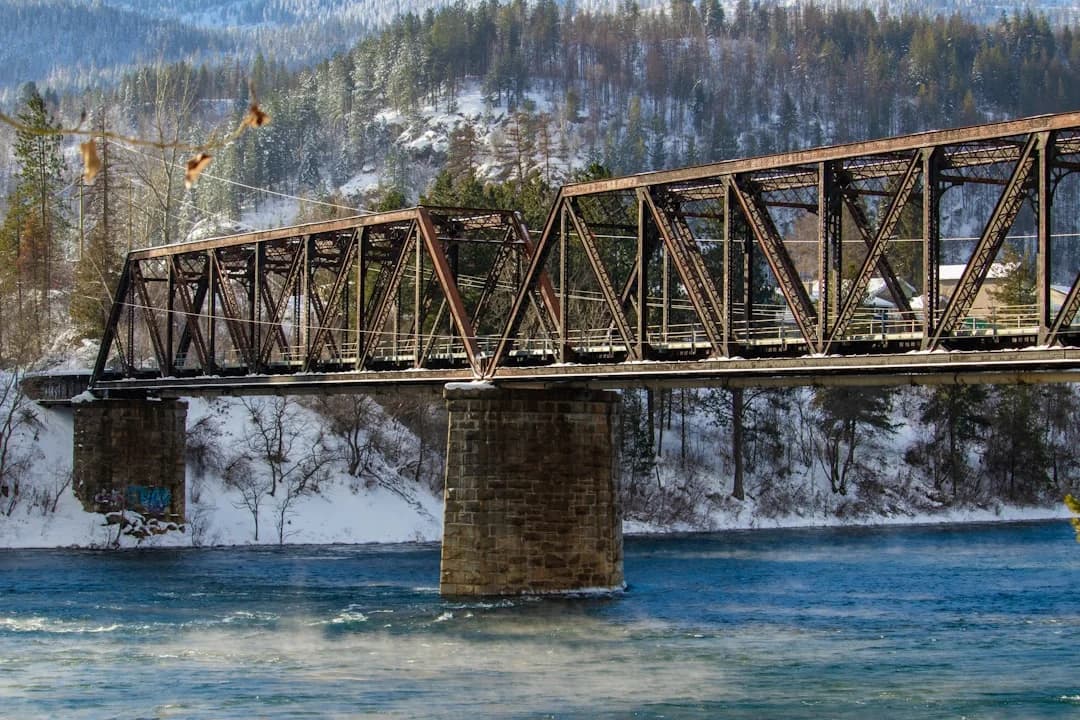
Photo by Shelby Bauman on Unsplash
The Pattullo Bridge replacement opens February 14, 2026 (BC), marking a pivotal milestone in Metro Vancouver’s transportation network. After years of planning, approval delays, and complex construction work, the stal̕əw̓asəm Bridge – known in English as Riverview – finally delivers a four-lane crossing between Surrey and New Westminster. The government and project partners say the milestone improves traffic flow, enhances safety, and provides dedicated space for pedestrians and cyclists, while signaling a broader shift in the region’s approach to bridge design and multimodal connectivity. The news comes with clearly defined next steps, including the permanent closure of the old Pattullo Bridge and an extended demolition timeline for the deconstruction phase. The opening is a data-rich moment for analysts tracking infrastructure renewal, urban mobility, and regional planning in British Columbia. (news.gov.bc.ca)
In practical terms, that means residents and commuters now have access to a four-lane crossing with a centre median and separated walking and cycling paths, designed to reduce bottlenecks and improve safety at one of the region’s busiest inter-city corridors. The updated crossing connects McBride Boulevard and the new Royal Avenue on-ramp in New Westminster with King George Boulevard in Surrey, creating a more direct and predictable route for daily commuters, freight movements, transit services, and visitors to the region. Government updates emphasize that the new structure not only increases capacity but also enhances resilience against peak-hour surges and weather-related disruptions. The milestone is also a signal to local businesses and regional planners that longer-term mobility strategies in Metro Vancouver are increasingly reliant on staged, multi-modal infrastructure that leaves room for future transit and cycling investments. (news.gov.bc.ca)
Opening with the news: Pattullo Bridge replacement opens February 14, 2026 (BC) after years of construction, with the four lanes of the stal̕əw̓asəm Bridge officially available to vehicle traffic at 7 a.m. on Saturday, February 14, 2026. The Pattullo Bridge itself remains closed to vehicular traffic, with the sidewalk still accessible to pedestrians and cyclists for a transitional period. Authorities note that demolition work on the Pattullo Bridge is slated to commence in late February 2026 and continue over roughly a two-year timeline, underscoring the significant scale of the project’s deconstruction phase. (pattullobridgereplacement.ca)
Section 1: What Happened
Four lanes open on stal̕əw̓asəm Bridge
The central development is the formal opening of the stal̕əw̓asəm Bridge (Riverview Bridge) with all four vehicle lanes available to traffic as of early morning on February 14, 2026. This marks the culmination of a major construction sequence that began in 2021 and involved coordinated work on adjacent road connections to ensure a safe and efficient transition for drivers moving between Surrey and New Westminster. The official stance from provincial authorities confirms that the new bridge features four lanes, a centre median for improved safety, and separated pedestrian and cycling facilities, designed to accommodate rising traffic volumes while prioritizing multimodal access. The bridge’s opening also represents the moment when the Pattullo Bridge’s utility as a regional crossing effectively ends, with demolition to follow in the coming years. (pattullobridgereplacement.ca)
Timeline highlights and key milestones include:
- February 14, 2026, 7:00 a.m.: stal̕əw̓asəm Bridge opens to four lanes of vehicle traffic; Royal Avenue on-ramp and McBride Boulevard access are integrated into the new crossing. (pattullobridgereplacement.ca)
- February 13, 2026: The Pattullo Bridge is permanently closed to vehicular traffic, signaling the transition from the old crossing to the new structure. Pedestrian and cyclist access to the Pattullo sidewalk continues for a short window, then gradually shifts as connections are completed. (newwestcity.ca)
- February 2026 onward: Removal of the Pattullo Bridge begins, with a multi-year deconstruction plan that will reconfigure the riverfront and surrounding roadways to harmonize with the new crossing. (newwestcity.ca)
A related construction notice from the provincial government underscored that traffic patterns would shift in late February 2026 as work on connecting roadways continued and the stal̕əw̓asəm Bridge assumed full responsibility for the corridor. The plan outlined temporary restrictions and closures to maintain safety and ensure efficient demolition work on the Pattullo Bridge. (archive.news.gov.bc.ca)
Block quotes from officials emphasize the significance of the opening beyond a single crossing:
“The stal̕əw̓asəm Bridge is a new regional landmark,” stated Mike Farnworth, Minister of Transportation and Transit, describing the bridge as not just a replacement, but a symbol of renewed regional mobility and safety. The four-lane crossing provides improved efficiency and more robust walking and cycling facilities, aligning with broader provincial goals to modernize critical infrastructure while expanding multimodal options for residents and visitors. (news.gov.bc.ca)
Section 1 further details the immediate impacts on traffic routing and connectivity. Drivers can access the new four-lane crossing via the McBride Boulevard and Royal Avenue on-ramp in New Westminster, or via King George Boulevard in Surrey. Several local access changes accompany the transition, including temporary closures to the Columbia Street loop-ramp and other connecting road segments during the bridging and ramp alignment work. These adjustments are designed to streamline the integration of the stal̕əw̓asəm Bridge with surrounding arterials and to reduce the burden on adjacent streets during the initial post-opening period. (pattullobridgereplacement.ca)
What happened to the Pattullo Bridge
The Pattullo Bridge’s closure marks a historic shift in Metro Vancouver’s infrastructure portfolio. After 89 years of service, the Pattullo Bridge’s vehicular lanes have been replaced by the stal̕əw̓asəm Bridge, with the old crossing slated for removal over the next two years. The current plan calls for the Pattullo Bridge to be completely removed once the new crossing is fully operational and all associated connections are decommissioned or repurposed. The phased approach to demolition is intended to minimize disruptions and ensure safety during the transition. The public-facing information from city and provincial authorities emphasizes that pedestrians and cyclists will retain access to the Pattullo sidewalk for a defined period before full removal activities proceed, and that alternative routes will be available via the new crossing and connected arterials. (newwestcity.ca)

Section 2: Why It Matters
Capacity, safety, and multimodal mobility
The stal̕əw̓asəm Bridge’s four-lane configuration with a center median and dedicated walking and cycling lanes is a central driver of the project’s value proposition. By expanding capacity and providing separated lanes for non-vehicular users, the bridge aligns with regional goals to improve safety outcomes and support growing demand for active transportation. Authorities have highlighted the design’s emphasis on driver safety, pedestrian safety, and predictable travel times, particularly in the Surrey-New Westminster corridor that sees high daily traffic volumes. The transition to a four-lane structure is framed as a strategic move to reduce bottlenecks and distribute traffic across a broader, more resilient crossing. (news.gov.bc.ca)
Transit and regional connectivity considerations are also central to the project’s rationale. The stal̕əw̓asəm Bridge connects to the Royal Avenue on-ramp in New Westminster and to King George Boulevard in Surrey, creating a direct north-south connection that improves access for local commuters and regional travelers. For transit users, the new crossing offers potential reductions in travel time and more reliable service windows, given the wider lanes and updated cross-section. The project is framed within broader regional planning efforts that prioritize improved mobility options and corridor resilience in the face of growth in population and freight movements. (news.gov.bc.ca)
Economic and employment implications also accompany the opening. The project represents a major capital investment, with construction activity driving local employment, supplier contracts, and associated economic activity. In addition to the immediate construction footprint, improved corridor efficiency is anticipated to influence business activity along the Surrey-New Westminster axis and in nearby commercial districts that rely on predictable access. Analysts tracking infrastructure-led growth note that successful project delivery can catalyze broader investment in adjacent areas, though the pace and magnitude of these effects depend on subsequent land-use planning and transit integration efforts. While direct economic multipliers from a single bridge project are often debated, the consensus among transportation economists is that lasting gains typically arise from a combination of reduced travel times, improved safety, and enhanced multimodal access. (news.gov.bc.ca)
Regional safety, climate, and resilience considerations
Beyond capacity, the stal̕əw̓asəm Bridge design emphasizes resilience and safety improvements relevant to climate and urban risk management. The center median and lane configurations are intended to reduce head-on and side-swipe collisions, while separated pedestrian and cycling facilities encourage active transportation and reduce potential conflicts with motor vehicles. The new bridge’s alignment and structural details also aim to support better drainage, wind resistance, and long-term durability in a region exposed to varied weather patterns. While the primary focus is safety and efficiency for daily users, the design choices reflect a broader shift toward robust, future-compatible infrastructure that can accommodate evolving mobility patterns, including increased cycling and scooter use. These considerations align with provincial transportation policy goals to advance safer, cleaner, and more reliable transportation options. (news.gov.bc.ca)

Photo by Michel Meuleman on Unsplash
Broader context: infrastructure modernization in British Columbia
The Pattullo Bridge replacement sits within a broader framework of infrastructure modernization across British Columbia. The government has prioritized major capital projects that modernize aging facilities, expand capacity, and improve multimodal access in urban regions. The combination of expansion, reconstruction, and deconstruction activities associated with the Pattullo replacement illustrates a common approach: replace aging assets with modern alignments, preserve critical pedestrian and cycling access where possible, and manage demolition in a way that minimizes disruption to ongoing regional movements. This approach resonates with other recent and ongoing projects across the province that seek to balance reliability for motorists with expanded options for transit, walking, and cycling. (news.gov.bc.ca)
Section 3: What’s Next
Next steps in construction and operations
With the stal̕əw̓asəm Bridge fully open for vehicle traffic, construction activity pivots to the deconstruction of the Pattullo Bridge and the completion of connecting roadworks that enable seamless operations across the corridor. The project timeline indicates that Pattullo Bridge removal is expected to occur over roughly two years, a schedule that accommodates phased demolition, road realignments, and the completion of associated multi-use paths and on-ramps. While the vehicle lanes are operational, the east-side multi-use path remains in development and is expected to open later in the spring, underscoring the project’s commitment to pedestrian and cyclist access concurrent with traffic movements. Planning documents and project updates caution that some closures and detours will remain in effect as connections are finalized. (newwestcity.ca)

Photo by Melvin Sng on Unsplash
Short- and mid-term impacts for drivers, pedestrians, and businesses
Drivers: The opening has immediate implications for travel patterns along the Surrey-New Westminster corridor. Access to the stal̕əw̓asəm Bridge through the McBride Boulevard and Royal Avenue on-ramp provides a direct route and is expected to shorten travel times for many commuters, particularly during peak periods. However, drivers should anticipate transitional changes as road connections are completed and as some lanes or ramps are reconfigured during the deconstruction phase. Local traffic advisories in February 2026 highlighted temporary closures and pattern shifts to support safety and work continuity. (news.gov.bc.ca)
Pedestrians and cyclists: Although the four-lane vehicle crossing is fully open, pedestrian and cycling access has had a staged approach. The Pattullo sidewalk remains open for pedestrians and cyclists for a defined window, with the east-side multi-use paths scheduled to open later in the season as bridging and path structures are completed. This phased approach seeks to maintain safe active-transport routes while the surrounding road network is reconfigured. City and provincial updates have provided the most detailed guidance on these timelines, including notices about temporary local street closures to facilitate construction activities. (newwestcity.ca)
Local businesses and communities: The opening is likely to influence foot traffic, tourism, and commerce along the corridor and in adjacent neighborhoods. Improved connectivity can attract customers who previously sought alternative routes or stranded times due to congestion. The longer-term economic effects will depend on how quickly the new path networks, transit connections, and pedestrian facilities are completed, and how effectively the region leverages the improved crossing to support local markets. Analysts note that while infrastructure upgrades can create immediate demand shifts, the sustained impact on commerce often requires complementary investments in streetscaping, parking management, and business readiness programs. (news.gov.bc.ca)
What residents and visitors should watch for
- Demolition milestones: Expect phased closures and demolition work to continue through late February 2026 and extend over the next two years. Project communications emphasize safety first, with traffic diversions and lane closures scheduled to adapt to work progress. The timeline suggests a rolling sequence of connection work and road reconfigurations designed to minimize disruption while removing the Pattullo Bridge. (archive.news.gov.bc.ca)
- Multi-use path completion: The east-side pedestrian and cycling paths are a priority for completion, with the aim of providing continuous active-transport routes as roadworks progress. The eventual completion of these paths is central to the project’s multimodal goals and has implications for local recreation, commuting, and accessibility. (newwestcity.ca)
- Long-term traffic patterns: With four lanes on the stal̕əw̓asəm Bridge, traffic distribution across the Surrey-New Westminster corridor is expected to become more balanced, though the pace and magnitude of the impact depend on how quickly ancillary roadworks are finished and how transit services adapt to the new crossing. Transit operators and city planners will monitor travel times, congestion hotspots, and incident rates to refine operational plans over the coming months. (translink.ca)
Next milestones to monitor
- February 2026: Full vehicle capacity on stal̕əw̓asəm Bridge confirmed; Pattullo Bridge demolition planning proceeds. Provincial communications indicated that the final linkages and ramp connections would be completed in the weeks immediately following the bridge’s opening, with subsequent demolition and site clearance proceeding over the next 24 months. (news.gov.bc.ca)
- Spring 2026: East-side multi-use path opening and related connections to McBride Boulevard and Dufferin Street are expected to be completed, providing continuous pedestrian and cycling routes along the corridor. City and project updates have signaled that multi-use path works would continue into the spring, with various segments opening as construction permits. (newwestcity.ca)
- Late 2026–2028: Pattullo Bridge removal continues, with ongoing road realignments and landscape/restoration work to complete the riverfront reconfiguration. Provincial release notes and project pages indicate a multi-year deconstruction phase, which will be monitored by transportation planning authorities, municipal staff, and community stakeholders. (archive.news.gov.bc.ca)
Closing
As of February 14, 2026, the Pattullo Bridge replacement opens February 14, 2026 (BC) and the stal̕əw̓asəm Bridge assumes full responsibility for cross-river traffic with a four-lane crossing, better safety features, and dedicated accessibility for pedestrians and cyclists. The broader narrative for Metro Vancouver infrastructure remains one of modernization, multimodal emphasis, and phased transitions that balance rapid mobility improvements with careful, staged demolition and road-reconfiguration work. For residents, commuters, and local businesses, the objective is clear: improved reliability, safer travel, and a bridge that serves as a cornerstone for regional growth while aligning with climate and safety priorities. To stay updated, follow the Pattullo Bridge Replacement Project’s official channels and your city and regional transportation advisories. (pattullobridgereplacement.ca)