Richmond Expands Bike Lane Network This Year..
Richmond, British Columbia is at a crossroads of urban growth and active transportation momentum. As BC Times continues to deliver independent journalism covering British Columbia, Vancouver, and the Pacific Northwest, readers will find a comprehensive look at how local policy, community voices, and practical engineering come together in the conversation around cycling infrastructure. The headline movement shaping the conversation is clear: Richmond expands bike lane network this year.. This year’s plans sit at the intersection of safety, access, and climate-conscious mobility, echoing broader provincial and regional goals to make active transportation a primary option for daily travel. For residents, commuters, and visitors, the changes promise new routes, safer crossings, and a stronger sense of place along Richmond’s evolving streets. As one city official recently noted, these projects are not just about paint on pavement; they’re about safer, more inclusive mobility for people of all ages and abilities. This article weaves together available official updates, community perspectives, and the practical implications for households, businesses, and the environment.
Why Richmond is accelerating bike lane expansion in 2026
Richmond’s decision to accelerate bike lane expansion this year is rooted in a broader plan to connect neighborhoods, business districts, schools, and transit hubs with a seamless, low-emission network. The city’s active transportation agenda emphasizes safety, accessibility, and multimodal connectivity, underscoring a shift away from car-dominant street design toward people-first streets. City documents and local reporting indicate a multi-year program that is now moving into a more expansive phase, with key corridors and corridor connections identified for 2026 and beyond. The plan is not happening in a vacuum; it aligns with provincial investments in active transportation infrastructure and with community-driven demand for healthier, more resilient neighborhoods. As the city navigates funding cycles and design challenges, residents and businesses are watching how these changes reshape daily life, from school runs to weekend errands to after-work recreation. In the words guiding policy, the city’s cycling network is planned to extend and improve connectivity along major corridors, while buffering traffic with protected lanes wherever possible. (citycouncil.richmond.ca)
“Richmond expands bike lane network this year..” is a framing phrase that captures the current push toward more and better cycling infrastructure, and it’s echoed in council briefings and local reporting about corridor improvements, protected lanes, and enhanced multimodal links. Community members are invited to participate in design conversations and to test new routes as they roll out.
The policy backbone: integrated, safe, and multi-use corridors
Richmond’s active transportation strategy emphasizes more than just stripes and paint. It envisions a network where bike paths seamlessly thread through neighborhoods, with safe crossings at busy intersections, improved wayfinding, and consistent maintenance. The city’s 2025 and 2026 planning documents describe a long-range objective: extend the cycling network to create continuous, buffered routes that connect with major arterials, transit hubs, and regional trails. In practice, that means a mix of protected bike lanes, multi-use pathways, and shared-use streets designed to reduce conflict between motor vehicles and non-motorized users. The result is a more attractive, safer, and more convenient urban environment for cycling as a primary mode of transportation. For those who track local governance, this is not a single-year project but a multi-year program with phasing dependent on land use, capital budgets, and the timing of adjacent urban development. (citycouncil.richmond.ca)
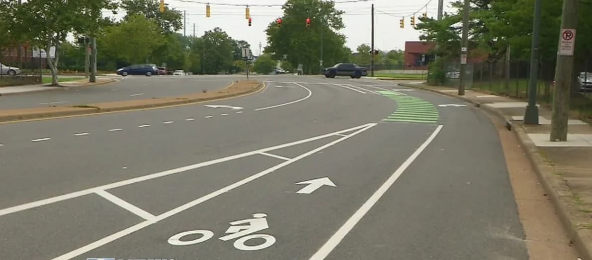
Key projects shaping the Richmond bike network in 2026
The city’s current and near-term plans emphasize several high-impact corridors and connected routes. While the exact sequencing and construction dates depend on design work, funding, and approvals, available official materials point to three core directions: extending the network toward the Railway Greenway, aligning with Steveston Highway, and building out westward connections through the Works Yard area. Here are the principal projects and their current framing based on city minutes and local reporting.

1) Extending the network from Lynas Lane to the Railway Greenway and Steveston Highway
One of the central strategic moves is to extend the cycling network from Lynas Lane in a direction that ties into the Railway Greenway and the Steveston Highway corridor. The aim is to create a more continuous, city-wide network that enables non-motorized trips across major neighborhoods and toward regional destinations. This plan is described in 2025 city documents as a long-range extension designed to improve connectivity and safety across multiple neighborhoods. The Works Yard development is identified as a potential enabler for further westward expansion, ensuring that new urban growth areas are wired into the active transportation backbone early in the process. As staff notes, the cycling network timeline will be linked to those adjacent developments and will be refined as detail design progresses. 340 lane-kilometres of facilities exist across the city, with expansion already occurring in areas near Steveston, underscoring a deliberate, measured pace of growth rather than a one-off project burst. (citycouncil.richmond.ca)
2) The Steveston Highway multi-use pathway and related phases
Steveston Highway has become a focal point for multi-use pathway investments, connecting Steveston Village, No. 2 Road, Shell Road, and beyond. City and local reporting indicate several phases of construction over the past two years, with FCAs and local contractors undertaking work to implement a continuous, safe pathway for pedestrians and cyclists. The project is designed to link to the wider network and to improve safety along a corridor that serves both residents and visitors to Steveston Village. The work has included various alignments, cross-section improvements, and coordination with nearby utilities and road upgrades to minimize disruption and maximize long-term safety and accessibility. In late 2024 and into 2025, reports identified completion windows for different phases, with ongoing work to finalize Phase 3 and a potential Phase 4 in subsequent budget cycles. The broader outcome is a more connected route that encourages cycling for daily trips as well as recreational rides along a scenic coastal area. (richmond-news.com)
3) No. 2 Road multi-use pathway and related east-west connections
Another critical element is the No. 2 Road multi-use pathway, which provides a vital link between Steveston Highway and Williams Road. Construction activity has been reported in 2024 and 2025, with the aim of delivering a continuous path that supports both active transportation and safer pedestrian crossings along a busy corridor. The No. 2 Road pathway is part of a broader strategy to knit together Steveston’s waterfront with inland neighborhoods, helping residents move efficiently without relying on personal vehicles. The project also ties into broader corridor improvements and pathways that connect to the Railway Greenway network, reinforcing a network effect across the city. While exact completion dates vary by phase, the city’s public communications and local outlets have highlighted progress and the anticipated linkage to Steveston Highway. (richmond-news.com)
The impact on residents, businesses, and the environment
The expansion of bike lanes and multi-use pathways changes daily life in tangible ways. For families commuting to schools, seniors seeking safer routes to shopping districts, and workers who want a reliable, comfortable way to reach transit hubs, new routes can translate to lower vehicle trips, healthier routines, and a more vibrant street life. The environmental benefits are driven by reduced vehicle emissions and cleaner air, reinforcing the city’s climate action goals. For local businesses, improved accessibility often translates to more foot traffic and better customer experiences, particularly along corridors that previously had limited safe crossing options. And for city planners, these projects provide opportunities to redesign street space to accommodate safe, separated modes for all ages and abilities, which in turn can reduce crash risk and improve overall mobility.
City communications emphasize that the safety and accessibility improvements are designed to be inclusive, including protected bike lanes, buffer areas, and frequent crosswalk enhancements. A common thread in official statements is that these changes are intended to “improve connections” and to encourage more people to choose biking for everyday activities, not just weekend recreation. The emphasis on safety is reflected in crosswalk upgrades, better lighting, and improved signal timing where necessary, aligning with the broader West Coast emphasis on safe, walkable, bike-friendly cities. While some of these changes are incremental, the cumulative effect across multiple corridors is a more resilient and flexible transportation system. (news.gov.bc.ca)
Quotes from local voices often highlight the social benefits of expanded bike networks. For example, a city communications piece on the Steveston corridor framed the project as part of a larger effort to improve access to schools, parks, and health services. "When completed, these connections will support safe and healthy travel for families and workers," one city spokesperson noted in public-facing materials. Community members who bike through Steveston or along the Railway Greenway emphasize how such routes create safer, more enjoyable experiences for weekend rides and daily commutes alike. These qualitative insights sit alongside quantitative updates, such as the total lane-kilometres and the number of miles of pathway planned, giving readers a fuller sense of the scale of the expansion. (richmond.ca)
How the funding landscape is shaping the pace of change
Funding for active transportation in Richmond is a critical lever in determining how quickly projects move from concept to reality. City minutes and provincial programs indicate that a mix of local capital budgets and provincial grants supports the expansion. In 2025, the Public Works and Transportation Committee discussed a comprehensive update on active transportation initiatives, noting that the cycling network’s timeline is tightly coupled with major development projects such as the Works Yard and other long-range plans. The committee highlighted that the total network now comprises hundreds of lane-kilometres and that ongoing expansions near Steveston have already added capacity. This background explains why some corridors progress in phases, with later phases contingent on design progress and budget approvals. The key takeaway: funding is not just about allocating dollars but about aligning investments with development timelines, corridor readiness, and safety enhancements. (citycouncil.richmond.ca)

A related line of reasoning is that provincial and municipal investment in active transportation often comes with complementary programmatic support—such as grants for safe crossings, lighting upgrades, and maintenance upgrades—to ensure longevity and safety. Richmond’s 2024-2025 public communications show a pattern of upgrading existing pathways while simultaneously creating new connections, which suggests a deliberate, staged approach to growth rather than a single, sweeping rebuild. The result is a more predictable, incremental improvement path that communities can experience year by year, rather than waiting for a singular big-bang project. (city.richmond.bc.ca)
A closer look at the community impact and experiences
Richmond’s bike lane expansion is not just a technical or budget exercise; it touches the day-to-day lives of people who live, work, and play in the city. A stronger active transportation network can encourage healthier habits, reduce traffic congestion near schools and workplaces, and improve access to local businesses along newly connected corridors. Community voices help to shape the design details—such as where to install protected lanes, how to time signal changes, and where pedestrian crossings should be elevated for safety. These discussions occur in council briefings, open houses, and local-news reporting, building a shared understanding of how the network should function in a busy suburban city.
Public engagement activities, road safety campaigns, and community rides—such as Island City, by Bike—play a critical role in demystifying new pathways and demonstrating the practical value of active transportation. The Island City by Bike tour, highlighted by the City of Richmond in 2025, showcases how residents and visitors experience the city’s waterfront, trails, and parks by bicycle. Such events help build support for further expansions and create opportunities for residents to provide feedback on route quality, safety features, and street life along the network. (richmond.ca)
The local press has tracked several concrete milestones in the city’s street network that illustrate progress and ongoing work. For example, the Steveston multi-use pathway projects—phases along Steveston Highway and No. 2 Road—have provided valuable links between neighborhoods and the waterfront, with specific completion timelines reported for those phases. These milestones serve as tangible evidence that the network is expanding, even as some segments remain under construction or in early design stages. Community coverage has also noted funding allocations for new segments and the positive reception from cyclists and pedestrians who are already benefiting from improved routes. (richmond-news.com)
A practical guide to the corridors proposed for 2026
- Steveston Highway multi-use pathway: Phases 1 and 2 were completed around 2024, with Phase 3 extending along the corridor toward Railway Avenue and beyond, improving connections to the No. 2 Road pathway and other segments. Construction impacts included lane closures in the active work zones, and the pathway provided critical links for pedestrians and cyclists along a major coastal route. Ongoing updates suggest continued work into 2025 and beyond to complete the chain of connections that feed into Steveston’s mobility network. (richmond-news.com)

- No. 2 Road multi-use pathway: Construction began in mid-2024 with the intention of linking Steveston Highway to Williams Road, connecting Steveston’s corridor with existing and planned pathways. Completion timelines have been shared by local outlets, and the project is a cornerstone of the Steveston mobility cluster. The pathway strengthens overall network connectivity and enables safer crossing between neighborhoods and the waterfront. (richmond-news.com)
- Lynas Lane-to-Railway Greenway extension: This planned extension is described in 2025 committee materials as a key connector that would advance westward expansion and align with the Railway Greenway. The timeline depends on the Works Yard development, with staff indicating that phase-level detail design will drive subsequent construction scheduling. The goal is to deliver a broad, city-wide cycling spine that supports safe, comfortable travel for all ages. (citycouncil.richmond.ca)
These corridors reflect a common West Coast approach: build core spine routes first, connect them to existing trails and greenways, and then extend coverage as funding and development progress. The regional context matters too: connecting with a larger cycle network invites more residents to consider biking as a viable everyday option, which in turn supports climate goals, public health, and local commerce. Where the plan is still evolving, the city makes a point of sharing design updates and inviting input from residents—an important part of building public trust for large-scale infrastructure projects. (citycouncil.richmond.ca)
A data-informed comparison: how Richmond’s approach stacks up against peers
To understand Richmond’s strategy, it helps to compare with peer cities that share similar urban forms and climate conditions. A practical approach is to look at corridor-focused, phased expansions that connect residential neighborhoods to business districts and transit hubs. The West Coast pattern emphasizes:
- A focus on protected bike lanes where traffic volumes and speeds make safety a priority.
- The creation and extension of multi-use pathways that separate pedestrians from cyclists and vehicles where feasible.
- The integration of new paths with existing rail trails and greenways to maximize connectivity.
- Ongoing funding streams that tie into capital budgets and provincial grants to ensure long-term maintenance and safety improvements.
While each city’s numbers vary, Richmond’s approach—extending from Lynas Lane toward the Railway Greenway, connecting Steveston Highway, and building No. 2 Road pathways—reflects a measured, connective strategy designed to deliver incremental improvements with clear safety and mobility benefits. This approach aligns with regional practices across the British Columbia landscape, where local governments emphasize safety improvements, enhanced multimodal access, and practical integration with transit networks. The city’s public updates and media coverage illustrate a steady cadence of progress, even when some phases require longer lead times for design, right-of-way, and funding approvals. (citycouncil.richmond.ca)
Table: Representative progress indicators for Richmond’s bike network (illustrative, based on official briefings and local reporting)
| Corridor / Project | Status (as of latest updates) | Notable features | Source notes |
|---|---|---|---|
| Lynas Lane to Railway Greenway / Steveston Highway alignment | In planning and phase design; westward expansion enabled by Works Yard | Planned continuous spine; protects vs. mixed traffic where possible | City committee minutes; local coverage (citycouncil.richmond.ca) |
| Steveston Highway multi-use pathway (Phases 1–3) | Phases 1–3 completed in stages; Phase 4 anticipated by budget discussions | Links Steveston to No. 2 Road; safety upgrades; no. 2 Road connection | Richmond News coverage; City updates (richmond-news.com) |
| No. 2 Road multi-use pathway (Steveston Highway to Williams Road) | Construction initiated; completion targeted for 2024–2025 windows; ongoing updates | Key east-west connector; improves access to Steveston corridor | Richmond News / City updates (richmond-news.com) |
What this table reveals is a pattern of progressive expansion with a clear emphasis on safety, connectivity, and community access. It also highlights the need for ongoing funding and phased design work, which is typical for local government infrastructure programs. For readers who track municipal cycling networks, Richmond’s approach demonstrates how a mid-sized city can build a credible, people-centered network step by step, balancing engineering feasibility with community priorities. The city’s own minutes indicate that a long-range plan exists, but the precise mileages added in a given year depend on capital allocations and adjacent development timelines. (citycouncil.richmond.ca)
Quotes that illuminate the journey
-
From a provincial perspective on regional transport improvements: “When completed, the new interchange will improve connections between Highway 99 and Steveston Highway to reduce queuing for vehicles in all directions, while improving regional transit and cycling connections.” This quote from the Government of British Columbia highlights how large interchanges can be design levers for active transportation in addition to vehicle efficiency. It reflects the logic behind infrastructure investments that support cycling as part of a larger mobility ecosystem. (news.gov.bc.ca)
-
From a community-oriented cycling event: Island City, by Bike emphasizes Richmond’s bike culture and the city’s ongoing investment in pathways, trails, and safe routes for residents and visitors alike. Events like these publicize the network’s benefits and invite residents to experience the changes firsthand, which helps build support for future expansions. (richmond.ca)
-
From local reporting on Steveston corridors: Steveston’s multi-use pathway phases have represented collaborative work among city staff, engineers, and the community to deliver a safer, more connected route for pedestrians and cyclists along a corridor that is both residential and tourist-friendly. These reports capture the practical realities of building and maintaining active transportation facilities in a busy urban area. (richmond-news.com)
Common questions and data gaps
-
What exactly will be completed in 2026? The city’s planning materials indicate a multi-year program with a phasing approach tied to adjacent developments, funding cycles, and design progress. While specific segment-by-segment completion dates are published in some updates, the comprehensive year-by-year schedule often remains fluid until final design and approvals are secured. Residents should monitor city notices and council agendas for the most current timelines. (citycouncil.richmond.ca)
-
How will Phase 4 Steveston Multi-Use Pathway be funded and prioritized? Richmond News reports suggest that Phase 4 could be part of the 2026 capital budget, contingent on council approval, with design work already underway and earlier phases completed in preceding years. This underscores how corridor expansions evolve through budget deliberations and capital planning. (richmond-news.com)
-
How do these expansions affect traffic during construction? As with any large-scale street projects, drivers should expect lane restrictions and some detours during active construction windows. City communications frequently provide maps and alternate-route guidance during the Steveston corridor work, reflecting a best-practice approach to minimize disruption while maximizing safety and long-term gains. (city.richmond.bc.ca)
Case study: A local bike-tour perspective on Richmond’s evolving network
The Island City, by Bike tour illustrates how residents engage with the network as it evolves. The event allows participants to experience Richmond’s waterfront trails, corridor connections, and protected paths from a cyclist’s-eye view. Publicizing such events demonstrates not only the practical growth of the network but also its social and cultural resonance—how a city can become a more bike-friendly place by narrating experiences and inviting feedback from the community. This case study exemplifies how local journalism, municipal communications, and community activities work together to normalize and celebrate active transportation. (richmond.ca)
The practical implications for 2026 and beyond
As the city’s corridors extend and the network connects more neighborhoods, residents will likely see tangible changes in daily life: easier access to parks and schools, safer commutes, and more reliable transit connections for people who combine biking with transit. Businesses along new or upgraded routes may experience more foot traffic, while housing developments along key corridors could see increased demand from buyers who value bikeable, walkable neighborhoods. Environmental benefits follow naturally: fewer car trips, lower emissions, and better air quality—contributing to regional climate goals. The city’s approach—emphasizing phased design, corridor connectivity, and community engagement—suggests that progress will be incremental but cumulative, producing a recognizable upgrade in Richmond’s mobility landscape over the next few years. For readers tracking West Coast urban changes, Richmond’s efforts align with broader regional patterns of improving active transportation as a central pillar of city planning. (citycouncil.richmond.ca)
FAQs: quick take on the Richmond bike lane expansion
-
Q: What is the overarching goal of the bike lane expansions in Richmond this year? A: To extend the cycling network, improve safety with protected lanes where feasible, and connect neighborhoods to major corridors like the Railway Greenway and Steveston Highway, enabling safer, more convenient non-motorized trips. (citycouncil.richmond.ca)
-
Q: Which corridors are the highest priority in 2026? A: The Lynas Lane to Railway Greenway alignment, Steveston Highway multi-use pathway (Phases 1–3 and beyond), and the No. 2 Road pathway are repeatedly highlighted in planning materials as priority corridors. Progress and budget timing depend on design steps and adjacent development work. (citycouncil.richmond.ca)
-
Q: Will there be traffic disruption during construction? A: Yes, as with any major infrastructure project, there will be lane reductions and detours during active construction periods. The city provides traffic advisories and signage to minimize inconvenience while prioritizing safety. (city.richmond.bc.ca)
-
Q: How can residents engage with the process? A: Residents can attend public meetings, participate in open houses, and provide feedback during design phases. City communications emphasize public involvement as an essential element of shaping the network to meet community needs. (citycouncil.richmond.ca)
A concise conclusion
Richmond’s bike lane expansion this year represents more than a set of new bike paths. It signals a strategic, community-driven shift toward safer streets, healthier living, and a more inclusive urban environment. The city’s corridor-focused approach—extending from Lynas Lane into the Railway Greenway, linking Steveston Highway with No. 2 Road, and weaving new connections into a broader network—embodies a practical, scalable model for mid-sized cities seeking to amplify active transportation. While the exact timeline for every segment remains subject to design and funding realities, the available updates and community reporting indicate steady progress and a clear commitment to making cycling a primary option for everyday mobility. For BC Times readers, this is a story about how local governance, engineering, and community engagement converge to shape a West Coast city that wears its commitment to the bicycle as a core element of urban life.
As the year unfolds, BC Times will continue monitoring council updates, project milestones, and community reactions to Richmond’s evolving bike lane network. The phrase “Richmond expands bike lane network this year..” captures a pivotal moment in the city’s journey toward safer streets and more vibrant neighborhoods. The coming months will reveal how these plans are realized in streets, sidewalks, and crossings—and how residents experience the city’s evolving cycling culture in real life.