Stal̕əw̓asəm Bridge Opening Boosts Vancouver Mobility
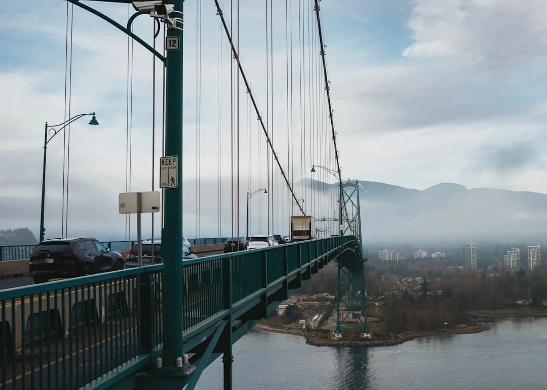
Photo by Albert Stoynov on Unsplash
The stal̕əw̓asəm Bridge opening marks a pivotal moment for Metro Vancouver’s transport network, delivering a new four-lane Fraser River crossing that directly replaces the Pattullo Bridge. As construction wraps up and traffic switches to the new span, travelers are already feeling the impact of safer, faster routes across the river. Government and project partners emphasize that the replacement is designed not only for today’s volumes but to align with modern seismic standards, enhanced pedestrian and cyclist access, and long-term reliability for goods movement throughout the region. The news is timely, data-driven, and consequential for commuters, transit riders, and local economies alike, with official updates detailing the opening timetable, the steps ahead for deconstruction, and the broader mobility implications for Surrey, New Westminster, and surrounding communities. The stal̕əw̓asəm Bridge opening comes after years of planning, with the official four-lane opening occurring in mid-February 2026, a milestone that closes a long chapter of the Pattullo Bridge’s life as a major choke point and transitions the river crossing to a modern, multi-modal corridor. (news.gov.bc.ca)
As planners and policymakers assess the broader significance, the opening is framed as a data-informed upgrade to regional mobility. Early traffic data, safety analyses, and travel-time estimates project meaningful gains for commuters who once faced longer trips and frequent delays around the Pattullo crossing. The government highlights that the stal̕əw̓asəm Bridge features four wider lanes with a central median and separated pedestrian and cycling paths, designed to improve safety, reliability, and throughput for vehicles and non-motorized users alike. With the new bridge fully open, the region’s transportation network begins a transition phase that includes deconstruction of the old Pattullo Bridge, road-widening efforts on adjacent approaches, and the gradual opening of connecting ramps and multi-use paths. This is more than a construction milestone; it is a reconfiguration of how people and goods move across one of the region’s busiest river crossings. (news.gov.bc.ca)
Section 1: What Happened
The Baseline: Pattullo Bridge replacement project on the Fraser River
The Pattullo Bridge Replacement Project, a major infrastructure initiative, began with construction on the stal̕əw̓asəm Bridge in 2021 and proceeded through a series of staged openings, closures, and transitions that culminated in a full four-lane crossing in February 2026. Project officials have repeatedly described stal̕əw̓asəm as a safer, more reliable crossing intended to modernize river traffic management and travel patterns across the Metro Vancouver region. The new crossing—referred to in First Nations language as stal̕əw̓asəm and in English as Riverview—was designed to integrate with surrounding road networks, improve resilience to earthquakes, and provide dedicated spaces for pedestrians and cyclists alongside motor vehicles. The official naming ceremony and-language guidance reflect a broader effort to honor local Indigenous nations while delivering functional infrastructure for the region. (news.gov.bc.ca)
Timeline of milestones: from partial openings to a full four-lane crossing
The project’s rollout followed a carefully choreographed sequence of partial openings and targeted closures intended to connect the new bridge to the surrounding road network while decommissioning legacy infrastructure. Notably, late 2025 through early 2026 featured staged access changes, with the first lane across the stal̕əw̓asəm Bridge opening in December of 2025, followed by an enforced closure window in February 2026 to complete road connections and utilities transitioning to the new crossing. On February 14, 2026, the four lanes of the stal̕əw̓asəm Bridge opened to traffic at 7 a.m., signaling the long-anticipated completion of the core crossing. In parallel, the Pattullo Bridge itself was closed to vehicle traffic, with pedestrian access curtailed in the days immediately surrounding the opening as crews completed final tie-ins and removed portions of the old structure. This sequence—partial openings, a controlled closure, and a final four-lane inauguration—was covered in real time by regional news outlets and confirmed by official agency updates. The total project cost has been reported at approximately $1.637 billion, underscoring the scale of the replacement and its expected operational benefits. (vancouver.citynews.ca)
Key structural and design features of the stal̕əw̓asəm Bridge
The new crossing is a single-tower cable-stayed design spanning 1,235 meters, with four wider lanes and a central median. Pedestrian and cycling facilities are separated from vehicle lanes to elevate safety for non-motorized users. Project materials and official summaries emphasize seismic resilience and modern roadway alignment that support smoother multimodal travel across the Fraser River. The bridge’s length and configuration translate into a substantial footprint on the regional transport map, with the design intent of reducing bottlenecks during peak periods and enabling more predictable travel times for routine commuting, freight movements, and transit reliability. As part of the broader Pattullo Bridge Replacement Project, deconstruction of the old Pattullo Bridge began in earnest as the stal̕əw̓asəm Bridge took on the primary role in river crossing. (news.gov.bc.ca)
Deconstruction plan for the Pattullo Bridge and the road network around it
With the stal̕əw̓asəm Bridge open, work shifted toward dismantling the Pattullo Bridge and reconfiguring the connecting roadways. The government page details a phased approach: removal of the Pattullo Bridge will take approximately two years to complete, enabling the creation of required connections for the Columbia Street on-ramp and the Highway 17 off-ramp, as well as the long-term integration of multi-use paths. The deconstruction timeline is inherently contingent on construction sequencing, weather, and safety considerations, but the official plan provides a credible forecast for the pace of Pattullo Bridge removals and the road network’s reconfiguration around New Westminster and Surrey. (news.gov.bc.ca)
A local and regional context: who benefits and how
Transportation authorities highlight the stal̕əw̓asəm Bridge as a critical upgrade for regional mobility. The four-lane configuration and separated paths respond to long-standing demands for safer travel across the Fraser River, reducing the need for detours and improving resilience in adverse weather or seismic events. In addition to the improvements for everyday drivers, the bridge is positioned to support freight corridors and supply chains reliant on efficient river crossing points. The alignment with adjacent road upgrades and the phased ramp openings is designed to minimize disruption while delivering a coherent network that improves travel times for residents of Surrey and New Westminster, as well as for commuters who traverse the corridor as part of longer regional trips. The project’s governance and project-management documentation reiterates these objectives and frames the stal̕əw̓asəm Bridge opening as a milestone in the region’s broader strategy to upgrade aging bridges and expand multimodal options. (news.gov.bc.ca)
Section 2: Why It Matters
Mobility gains and safety improvements across a busy corridor
The immediate and most widely cited rationale for the stal̕əw̓asəm Bridge opening is enhanced mobility. The four-lane bridge, with a central median and barrier-separated walking and cycling lanes, is designed to reduce congestion, shorten commutes, and offer safer passages for pedestrians and cyclists who previously had limited, shared-space options on an aging crossing. The official updates emphasize safety improvements and reliability, aimed at supporting a smoother, more predictable travel experience across the river for motorists, transit riders, and non-motorized users alike. These claims are grounded in the bridge’s design features and the region’s traffic-management objectives, which prioritize resilience and efficiency in a corridor known for peak-period strain. The early traffic and safety analyses associated with the opening are intended to translate into measurable outcomes for travel times and incident rates, with the expectation of long-term benefits as the surrounding connections come online. (news.gov.bc.ca)
Economic and goods-m movement implications for Metro Vancouver
Beyond individual travel time savings, the stal̕əw̓asəm Bridge opening has implications for regional goods movement and freight corridors. The Fraser River crossing is a critical link for trucking routes that move goods between the eastern and western halves of the Metro Vancouver region, and across British Columbia. With a modernized crossing, the region can anticipate more reliable scheduling for deliveries, better integration with port movements, and reduced vulnerability to maintenance-induced disruptions that previously could ripple through supply chains. The cost and scale of the project—paired with the replacement’s long-term maintenance and operation plans—signal an investment in the region’s economic competitiveness. While the direct tolling policy is still subject to ongoing policy discussions and project governance, the four-lane configuration and improved traffic flow are expected to yield productivity gains for businesses that depend on timely, predictable crossings of the Fraser River. The public-facing materials from the Pattullo Bridge Replacement Project provide context for how this bridge opening ties into broader economic objectives. (vancouver.citynews.ca)
Regional equity and accessibility for communities on both sides of the river
A central element of the stal̕əw̓asəm Bridge opening is its emphasis on multimodal accessibility. The dedicated pedestrian and cycling lanes reflect a commitment to providing equitable mobility options, enabling residents who do not rely on cars to access essential services and job opportunities across the river. By connecting with broader active-transport initiatives and the planned integration of a multi-use path network, the project aligns with regional goals to promote healthier transportation choices, reduce greenhouse gas emissions, and support a more inclusive mobility ecosystem. The government and project teams have underscored that the opening is not just about vehicles moving faster but about expanding choices for people who bike, walk, or rely on transit. (news.gov.bc.ca)
Public communications and stakeholder sentiment
The stal̕əw̓asəm Bridge opening has been a focal point for public communications from multiple agencies, including the Government of British Columbia, TransLink, and municipal partners. Official statements stress the bridge’s safety design, its role in a longer-term network upgrade, and the transitional steps required to retire the Pattullo Bridge from vehicular service. Local news reports have documented the public’s reaction in terms of travel-time improvements and the sense that a long-awaited project is finally delivering tangible progress. While stakeholders acknowledge ongoing work to complete connections and pathways around the bridge, the consensus across sources points to a net positive in terms of mobility, safety, and regional resilience. (news.gov.bc.ca)
Section 3: What’s Next
Next steps in the opening sequence and network integration
With the stal̕əw̓asəm Bridge fully open, the Pattullo Bridge deconstruction proceeds on a parallel schedule. The Pattullo Replacement Project’s current plan outlines a staged approach to removing the old bridge while ensuring essential access for pedestrians and cyclists continues through the transition. The immediate next steps include finishing the Columbia Street on-ramp in New Westminster and the Highway 17 off-ramp in Surrey, both of which are tied to the partial removal of Pattullo Bridge sections. The Pattullo Bridge Replacement Project page indicates that these ramp openings are planned for summer 2026, with multi-use paths and related connections being completed after partial Pattullo removals. Transit and traffic patterns will continue to adapt as these components come online. (pattullobridgereplacement.ca)
Multi-use paths, active transportation, and summer 2026 milestones
An essential element of the post-opening period is the completion of multi-use paths and connectors that accompany the stal̕əw̓asəm Bridge. The project’s communications note that pedestrian and cycling access will be expanded through the east-side multi-use path and related connections in the months after the opening, with full access anticipated by spring 2026 for east-side pathways and remote-access points. The summer 2026 timeline also includes the planned opening of the Columbia Street on-ramp in New Westminster and the Highway 17 off-ramp in Surrey, which depend on Pattullo Bridge deconstruction progress and the sequencing of road-work across both sides of the river. These developments are critical to realizing the bridge’s full multimodal capacity and ensuring that non-vehicular users have safe, direct routes to transitions across the river. (news.gov.bc.ca)
Summer 2026: the final integration of the new connections
As the Pattullo Bridge replacement works advance, summer 2026 is expected to bring the completion of several key access points. The Columbia Street on-ramp in New Westminster and the Highway 17 off-ramp in Surrey are among the elements slated for opening during the summer 2026 window, contingent on the pace of Pattullo Bridge removal and other connecting-road works. The Pattullo Bridge Replacement Project’s official materials outline a careful, staged approach to ensure safety and continuity of movement as the old bridge is dismantled and the new network is fully wired into the regional system. For commuters and businesses, this means a gradually expanding set of routes and options, rather than a single event at once. The goal is to provide stable, predictable travel patterns as the region completes its transition from Pattullo Bridge to stal̕əw̓asəm Bridge. (pattullobridgereplacement.ca)
What to watch for in the immediate months ahead
- Traffic patterns and travel-time metrics: Expect refined scorecards from government and transit agencies showing improved speeds and more reliable crossings as four lanes remain in operation and as ramp connections finalize.
- Pedestrian and cyclist access: Continued rollouts of multi-use paths connect to the bridge, expanding non-vehicular mobility options and encouraging mode-shift towards active transportation.
- Roadway reconfigurations: The Columbia Street on-ramp and Highway 17 off-ramp openings will reconfigure local traffic patterns and influence neighborhood accessibility.
- Deconstruction milestones: Pattullo Bridge removal activities will progress in stages, with safety precautions and detours communicated through DriveBC, Pattullo replacement channels, and TransLink advisories. (news.gov.bc.ca)
Closing
The stal̕əw̓asəm Bridge opening is not just a new crossing over the Fraser River; it is a strategic upgrade in a region defined by growing populations, vibrant economies, and a climate-driven push toward safer, more efficient multimodal transportation. The four-lane structure, with dedicated pedestrian and cycling facilities, embodies a data-driven response to congestion, safety concerns, and the need for resilient infrastructure in the face of natural and man-made disruptions. As the Pattullo Bridge deconstruction proceeds and connecting roadways take shape, the region will begin to realize the full benefits of this modern crossing. For readers and travelers seeking timely updates, official channels such as the Pattullo Bridge Replacement Project site, DriveBC, and TransLink advisories will be the primary sources of ongoing information, with additional context provided by BC Gov News and regional media coverage. The stal̕əw̓asəm Bridge opening thus represents not a final achievement but a significant milestone within a broader program of transformation for Metro Vancouver’s river crossings. (news.gov.bc.ca)
As the commute landscape evolves, readers can stay informed through regular updates from the Pattullo Bridge Replacement Project and TransLink, especially as summer 2026 brings the completion of critical ramps and multi-use paths. The bridge’s First Nations naming reflects a lasting commitment to regional identity and cultural recognition, while the engineering milestones underscore the region’s capacity to deliver complex infrastructure projects on a predictable timeline. With the stal̕əw̓asəm Bridge opening, Metro Vancouver emerges with a stronger, safer, and more versatile crossing that serves as a backbone for growth, connectivity, and sustainable mobility for years to come. (news.gov.bc.ca)